Hello everyone welcome in SONU LIVE ,in this article I will provide you all important questions related CLASS 6TH GEOGRAPHY NCERT chapter 4 and also important questions for UPSC.
SUMMARY OF THIS CHAPTER FOR UPSC
Q. What is map?
Ans- A map is the representation of the surface of the earth, or a part of it is drawn on the flat surface according to the scale. Q. Explain different types of maps.
Ans-Political maps:- It represent the series towns village and different countries and state of the world with their boundaries are called political map physical map Physical map:- These are the maps which shows natural features of the earth such as mountains plateau Plains rivers Ocean City are called physical or relief maps and thematic maps:- Some maps focus on specific information such as road maps rainfall maps, maps showing distribution of forest industry etc are known as thematic maps.
Q. What are the components of map ?
Ans-There are three components of maps distance, direction and symbol.
Q. What do you mean by scale?
Ans-Scale is the ratio between the actual distance on the ground and the distance shown on the map.
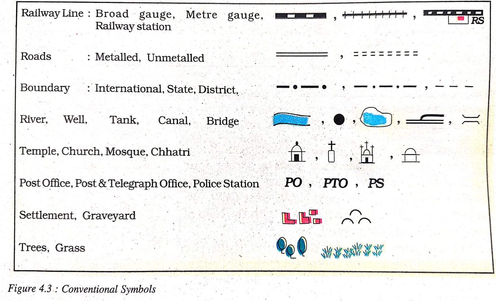
Q. Explain about conventional symbol.
Ans-Conventional symbols:- The symbols and science that are accepted by all are known as conventional symbols. The various tools in the conventional symbol are the combination of dots lines colors and alphabets.
Q. What is sketch?
Ans-A sketch is a drawing mainly based on memory and sport observation and not to scale.
Q. Explain about sketch map and plan.
Ans- A rough drawing is drawn without scale and is called a sketch map, the plan is a drawing of a small area on a large scale .
NCERT Solutions for Class 6 Social Science Geography Chapter 4 Maps
- Answer the following questions briefly:
(a) What are the three components of a map?
(b) What are the four cardinal directions?
(c) What do you mean by the term ‘the scale of the map’?
(d) How are maps more helpful than a globe?
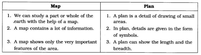
(e) Distinguish between a map and a plan.
(f) Which map provides detailed information?
(g) How do symbols help in reading map?
Answers:
(a) The three components of a map are—distance, direction and symbol.
(b) The four cardinal directions are—North, South, East and West.
(c) The term scale of the map’ means the ratio between the actual distance on the ground and the distance shown on the map.
(d) Maps provide more information than a globe, globe can be useful when we want to study the earth as a whole and but when we want to study only a part of the earth, as about a country or a state, globe is of little help. In such a situation only maps are useful.
(e) Differences between a map and a plan.
(f) Large scale maps provide detailed information because of the following reasons.
Large scale maps are drawn on big-sized papers.
Maps are of very large size. They have more space to depict more information.
(g) With the use of symbols maps are more informative and easier to read because of the following cause The symbols are of the features in true form.
Language does not put any problem in understanding the feature.
Even the less educated can understand the information easily.
2.Tick the correct answer:
(a) Maps showing the distribution of forests are
(i) Physical map (ii) Thematic map (iii) Political map.
(b) The blue colour is used for showing
(i) Water bodies (ii) Mountains (iii) Plains. (c)A compass is used
(i) To show symbols (ii) To find the main direction (iii) To measure distance. (d) A scale is necessary
(i) For a map (ii) For a sketch (iii) For symbols.
Answers:
(a)—(ii), (b)-(i), (c)-(ii), (d)-(i).
Read More:- https://sonulive.in/class-6th-geography-ncert-chapter-3